k51) German radars in this area
Part 1. Wurzburg Riese FuMO 214, Scheer FuMO 15 and FuMO 214-15
(Arnika, Flieder und Linde)
k51) German radars in this area
Part 1. Wurzburg Riese FuMO 214, Scheer
FuMO 15 and FuMO 214-15
(Arnika, Flieder und
Linde)
Intention for the coast fortress
and radar pages:
The intention is not to copy the
more professional style you find on many other sites, which in my
opinion takes a lot of work to present little info. It is no good
reason for shown a lot of small picture with inadequate text,
with the possibility to click on the picture to have a little
larger micro-picture without text, but show some observations and
references I have collected with actual information on the actual
page or referred to when too much to display on the first page. I
am aware that it may not look professional, and I am critized for
it, but professionalism doesn't make anything alone
 |
 |
 |
 |
 |
 |
 |
 |
 |
 |
 |
WPG |
 e98 tactical radar
k58 further German radar sites in Norway
Cajus Bekker: Radar-Duell im Dunkel (1958)
Selv om radar etter hvert fikk sin
utbredelse, må en ikke glemme lyttepostene som ble satt opp på
svært mange forskjellige steder. Se Terschelling en zijn rol in de
Luchtoorlog "Tigerstelling" door P. van Leuwen.
Boken er dessverre ikke lengere tilgjengelig, og jeg har fått
tilsendt en kopi fra Gerrit de Ruiter
Translation
of the German site names:
| Arnika=Tromö (Arendal) | Königkerze=Kragerö (Stabbestad) | Tanne = Tarva |
| Flieder=Flekkerö (Kristiansand) | Linde=Lista | Thymina = Titran ( on Fröya) |
| Fliege = Fedje or Florö ?? | Nussbaum=Nesodden | Trauerweide = Tronsaasen |
| Fichte = Fedja | Steineiche
= Sandvik (north of Malöy) |
Veilchen = Vigra |
| Frauenschuh= Ferkingstad (Karmöy) | Storch=Stord | Wacholder=Varhaug |
| Hainbuche=Hankö | Storchschnabel = Selbjörnsfjorden |
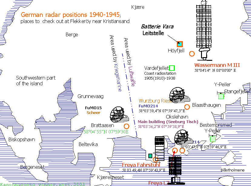
2. Map showing the sites
where German radars have been installed at Flekkeröy
Island outside
Kristiansand, it was another VHF radio installation at Stangfjellet,
but I haven't any strong clues about it,
possibly radio direction finding hut. It was burnt down sometime in the 60's.
Note the coast radio station at Vardeheia, see page R11 for further info.
Believe that the German radar at Brattaasen
wasn't a Wurzburg Riese FuMO214, althouth the parabolic
dish may
look like it, it was an aluminium type - possibly built at
Zeppeliner Bau, but it is more likely that the radars planned in
the end of the war was not a type the Germans knew had bad
problems. So we believe the radars at Nordberg
Fort and Brattaasen were 3GHz microwave type FuMO15
Scheer (Kriegsmarine), however the Germans never
succeeded in
operating those radars, and an English document claims that it
was not in use, this is probably for the reason that Germans
had problems in manufacturing the microwave parts, see Fritz Trenkle: Funkmeßverfahren bis 1945.
. You may notice that the sockets for the Wurzburg Riese are much
lower than what you find at Brattaasen and
Nordberg fort, this may be an indication; pointing in the
direction that it was different types of installations.
Note: Two small islands are called Daudmannsholmen,
one where probably were a VHF Direction Finder;
on the south tip - not the Daudmannsholmen is a stone house which
was used in the 60's as coast station transmitter (LGR),
the other "Daudmannsholmen" is is south of Kjaereneset,
it is some remainders from the Germans there, but we have no idea
what it was used for. If you have further
info I'll be pleased to hearing from you.
 |
 |
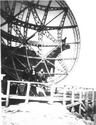
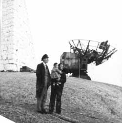
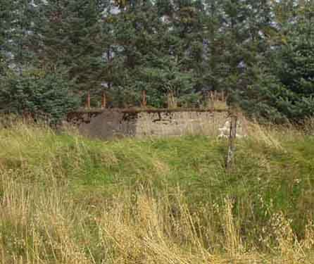
3. Wurzburg Riese FuMO214 (the lowest of the two, not
Blåsthaugen - Luftwaffe) at Okslehavn Flekkeröy
visited by some local boys in the late 40's Pos.: 58° 03' 47,8"N
07° 59' 46,9"E
This was transported to Råö, Kungsbacka
in 1950
4. FuMO214 (Wurzburg
Riese for Luftwaffe) site at Blaasthaugen, Flekkeröy,
Pos.: 58° 03'
59,4"N 07° 59' 47,3"E
Have received the following comment about WR: Freya did a good job for
gefechtsfeldübersicht (battlefield overview).
WR on its own was not that effective.
Did you
read about "kombinierte Nachtjagd"? Therefore mostly 2 WR were used together with
one Freya, which gave a general overview over the airspace, and
allowed to use the WR's for directing anti aircraft
artillery an guiding
of the Messerschmitts.
The beam characteristic of WR is more directed to a certain
point. due to that it is harder to observe the
whole airspace with such a device.
but on the other hand it is very usefull for tracking a
single aircraft for example.
so if a
freya is used in combination with WR,
you can keep the overview over the battlefield, and at the
same time you can determine an exact bearing
for anti aircraft artillery or hunters.
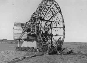
5) Wurzburg Riese
| 5a) |
 5b) 5b) |
5a) Wurzburg Riese FuMO214 (the lowest of the two) at Okslehavn
Flekkeröy visited a few years ago.
Pos.: 58°
03' 47,8"N 07° 59' 46,9"E (near Bestemorsmed?)
5b) Blaasthaugen (the
highest of the two sites), pos: 58° 03’ 59,4N 07° 59’
47,3"E
 |
 |
| 5c) Målskisse for Wurzburg Riese (nedre, Okslehavn) |
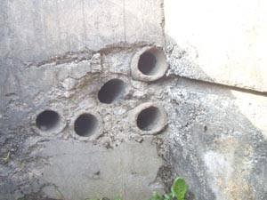
5d) Kabelinnføringsrør i bakk-kant for Wurzburg Riese (Okslehavn), de er 10,5cm I.D |
5e) Antenne-detalj for radar på Ryvingen. Er det virkelig
Wurzburg Riese?
(Martin M. Nøding)
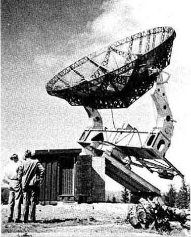
6) FuMO214 antenna - once used
in this area - still in use at Swedish observatory for
laboration, and it is in good shape!
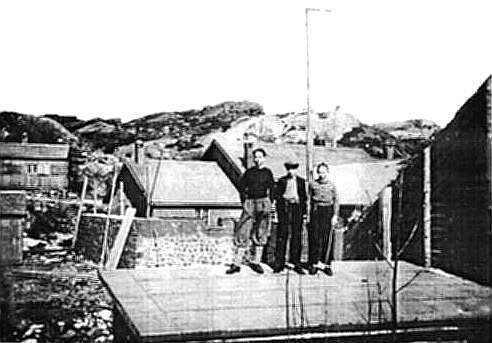
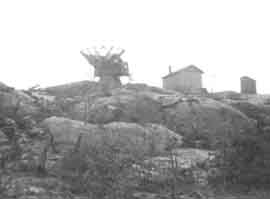
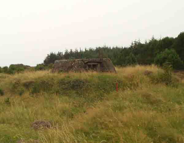
7a) Luftwaffe's Main building at Okslehavn,
Flekkeröy vistited by some local boys just after the war
We really don't have the faintest idea what has been here,
everything was removed by the Englishmen - as top secret - before
any Norwegian troops were allowed to see the place, but regarding
the heavy concrete walls surrounding the
building indicates that it may have been the operational center,
perhaps it had a "Seeburg Tisch". The place is well
hidden
behind smaller mountains so the walls becomes quite mysterious.
Position: 58° 03' 56,2"N 07° 59' 38,9"E
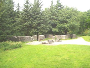
7b) What it looks like today.
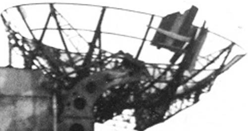
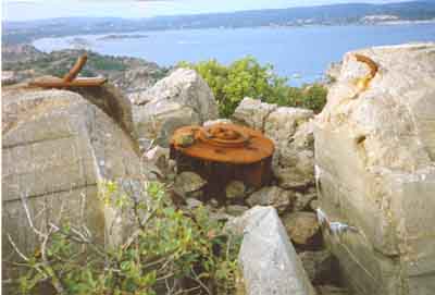
8) Bringing the
FuMO214-15 (Scheer) antenna from Brattaasen to Mövik Kanonmuseum
(MAA 6/502) in 1997:
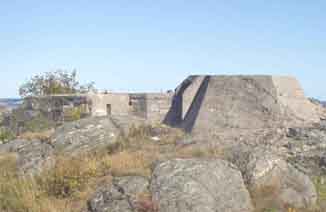
Brattaasen radar site
(Kriegsmarine).
Picture taken from "Freya-Fahrstuhl" site at
Daudmannsholmen (2003.07.30)
 9a. HP and Jakob preparing for the work |
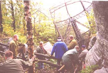 9b. It was a hard job for a douzen men, inspite that the total weight of the dish is hardly 100kg |
 9c. |
 9d. |
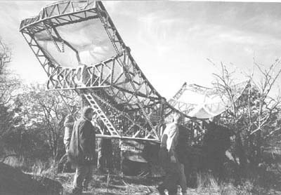
9c) Used three
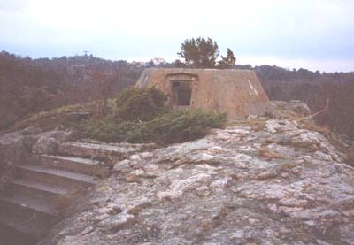
saturdays, here is the second part on the way to Kanonmuseet
9d) The Brattaasen site (MAA 6/502) seen from where the dish spent the last 50
years, splendid colours, November 1997!
GPS position: UTM 32V 04
40.200E, 64 36.350N
 |
 |
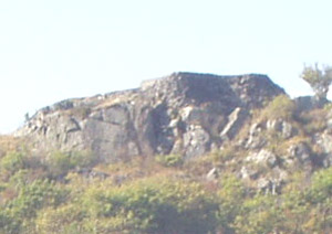 |
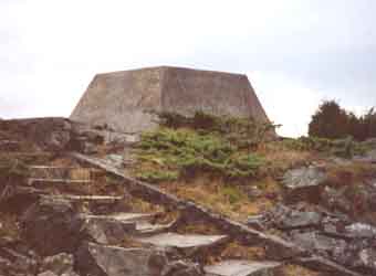
9e) Brattåsen radarstilling sett vest- og østfra (nedefra),
selve antennefundamentet er 216cm høy!
10a) Atkomst for radar på Brattåsen pr august
2003:
Gå til Okslehavn, nesten til Daudmannsholmen/Steinhuset. Herfra
går det en sti
over svabergene vestover, under Brattåsen går det en litt
mindre synlig sti til venstre oppover i hellingen,
men greit å følge opp forbi nedlagt trafostasjon og en veldig
lang trappe opp til toppen. Du vil ikke se et
eneste skilt om at det er forbudt område, ei heller er det
stengt med noe gjerde.
Følger du nedover veien til høyre vil du snart se et skilt med Entrance
Prohibited/Adgang forbudt,
men du skal opp til venstre og derfor helt lovlig. Dessuten er
alle bunkere murt igjen og det meste er jevnet
med jorden, det mest hemmelige i området har vært hvordan
Forsvaret har slengt fra seg søppel. Ved Brattåsen
har til nå bare funnet en ventilasjonskanal.
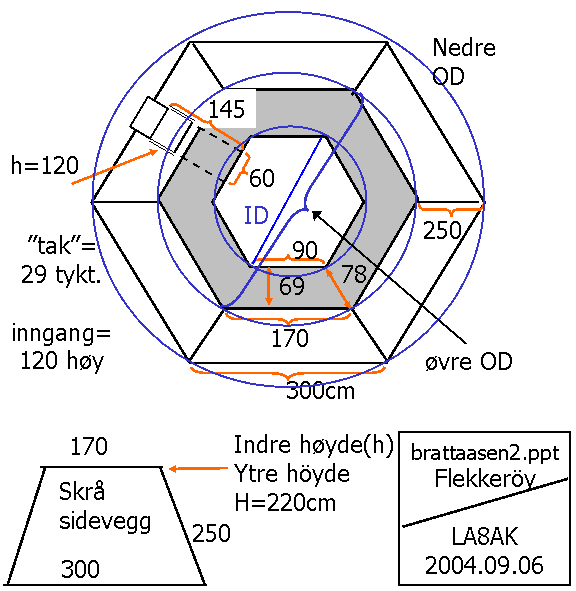
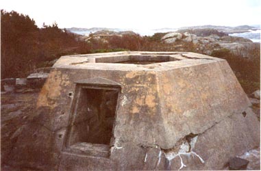
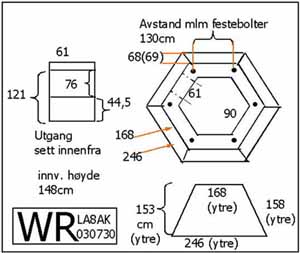
10b. Målskisse for Brattåsen stillingen. Mot øst er det lav bunker/bygninger på siden, høyde
161-167cm,
mens i syd er det 50-80cm murkant. En kan undre om radaren bare
er ment brukt syd og sydvestover, med begrensning for retning
0-60°.
(brukbar QTF 60-360, av mulig 360° med 0° elevation)
Brukes til å sammenligne målene for de andre stillingene.
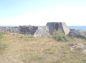
11.
HKB21/979 Ny Hellesund. Here was a Wurzburg Riese FuMO214-15
until 1960! (Kriegsmarine)
I never quite understood why it
has been so important to damage the remainders of German sites
and let it look like
Jerusalem in year 52, ask the Army? Many similar places may cause
tragedy to animals to be trapped in dangerous holes.
The hate towards Germans still exists, and iIt has been the
tradition to destroy German ex-army equipment, and as
we want to the best in the class, we have rules to destroy
equipment which would normally be possible to buy
on the surplus marked in related NATO countries. It has been
claimed that it was ruled out by the Marshall Aid
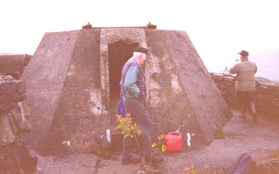
12)
 a) a) |
b) |
a) Radarstasjonen på Ryvingen (Mandal), men
hvilken type er det egentlig? Radaren ble angivelig aldri ferdig
montert,
det lå en lekter med forskjellige deler i havna nedenfor.
(Copyright M. M. Nøding)
b) Antenne-detalj for radar på
Ryvingen.
(Copyright M. M. Nøding)
Refr.: Ryvingen Beacon, position:
57°58' 06" N, 7°29' 30" E, Maidenhead
Locator: JO37RW
13)
Radar II på Ryvingen, delvis liksom kamuflert,
men i virkeligheten er dette en trekonstruksjon (dummy) til å
forvirre
motparten. En kan undre seg over at den ikke en gang var malt,
men det problemet med så mye av de tyske efter-
latenskaper, de var ofte pillråtne - 10 år efter krigen
sluttet. (Copyright Martin M. Nøding)
Et annet bilde fra samme sted finner man i Trenkle "Die
deutschen Funkstörverfahren bis 1945, side 143.
14)
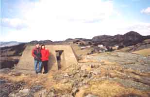
FuMO214 Wurzburg Riese, Vedeheia, Justöy (Lillesand)
and Tromöy (Arendal). See more info on pg K.53
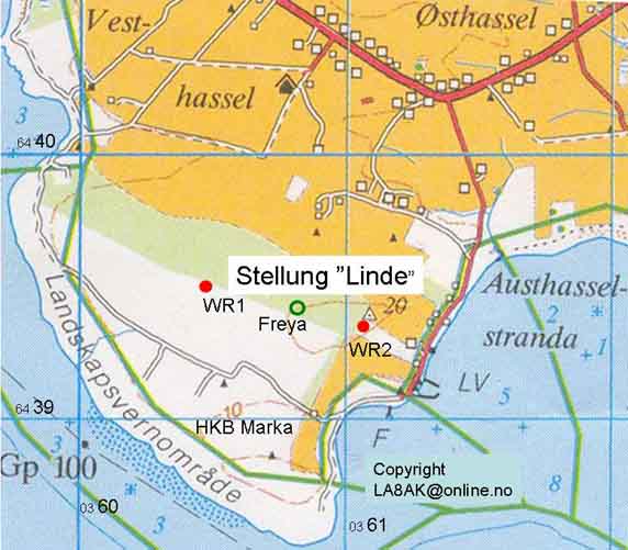
15. Radarer på Stellung "Linde"
(Luftwaffe) [v/HKB 23/978 Marka
(Lista)]
Vestligste Wurzburg Riese (FuMO214), UTM
posisjon 32V 036 472, 64 39 492.
Stillingen er meget lett synlig sør for granskauen et langt
stykke langs veien forbi kommandotårnet.
Om søk efter Freya:
Mente å ha funnet Freya stillingen i posisjon 0360.881 øst,
6439.412 Nord (beregnet posisjon basert på tysk kart: UTM 60.847
Ø, 39.422N), men Erik Ettrup mener det må være en
Flak-stilling
Da er det bare å forberede ny tur på alle fire om det kan være
noe å finne 34m lenger vest og 10m nordover. Se forøvrig side k33
Litt sør for østligste WR stilling følger en skogsvei (rydning
i skogen) 200m vestover til før det er en sving til høyre, og
finner en sti mellom grantrærne. Hvis en kommer ut på sørsiden
av skaugen ved et steingjerde, kan en prøve å følge det
tilbake innover, men det er umulig å følge innover akkurat der,
må gå inn 20-30m øst for det, mellom grenene ser man at det er
en sti.
x
 |
 |
Østre Wurzburg Riese FuMO214 (Luftwaffe), posisjon 32V 0361.080
øst, 6439.380 nord, innerst i nordvestre hjørne av en kornåker
med granskaug mot nord og vest.
Vanskelig å se før en snubler over denne stillingen.
Fundamentet er delvis målt opp og følgende kan bemerkes: OD
øverst 350cm, max ID 180c og indre høyde 147cm.
Ser ut til å være kraftigere fundament enn Luftwaffe stillinger
i Okslehavn (Flieder), noe lignende som Brattåsen, men ikke så
høy.
NB. Linde (Marka) er forøvrig det eneste stedet
jeg har sett festestagene fortsatt finnes - gjelder begge
WR-stillingene,
6 stk ca 1/2m lange 30mm dia. gjengete stag til å feste selve
radaren til betongfundamentet.
 |
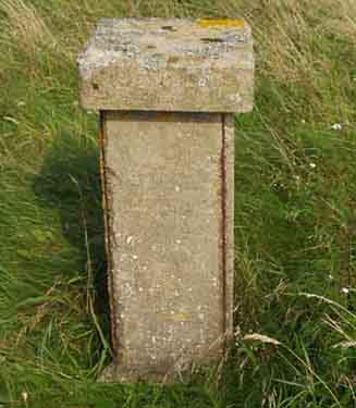 |
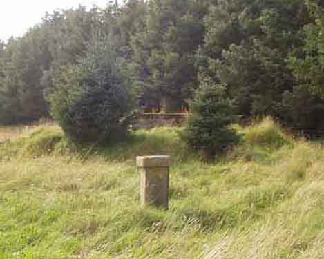
Undrer hva denne betongstøtten er? Det ligger metalltråd i
hjørnene, festet med kramper. Over den er det en tilhugget stein
som passer inn på støtten.
Det ben i hvert hjørne og noen cm hulrom under, men bare
småstein - ikke hull videre nedover. Samme steinstøtte skal
angivelig være bak FuMO214-15 marine-radarstillingen på
Nordberg Fort.
Kart over "Stellung Linde"-området med de tyske
radarstillingene (Marka).
Se forøvrig side K33 om det som ikke har
med radar å gjøre for dette området.
Kopiert utsnitt av kart for "Farsund, Blad 1311 II,
Bestillingsnr. 185, M711 - 1:50 000, utgave 1994".
UTM-rutenett er 1000x1000m. Omtegnet i powerpoint.
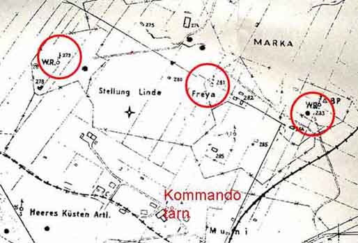
Note: A copy of German map showing installations
at Lista is available at Lista beacon (Lista fyr) for NOK300,-,
here is shown a smaller part of it.
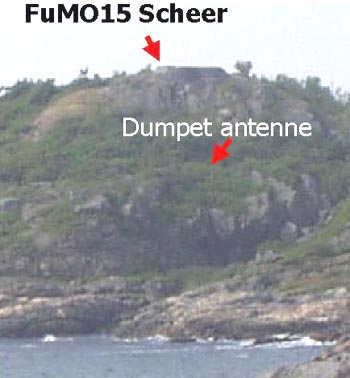
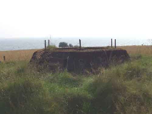
16) FuMo15 'Scheer' site at MKB5/503 Nordberg (Kriegsmarine, Lista) [LA3VW+XYL]
The main difference between FuMO214 Wurzburg Riese and FuMO15
Scheer is the antenna feed horn and Berlin 9cm transceiver. When
the set it provided with 9cm RF components only, it is designated
as FuMO-15. Ordinary, however provision was made so that the 9cm
components could be used alternately with standard Wurzburg
elements, and for this arrangement the compound number
FuMO-214/15 was used. The advantages of the Scheer over the Giant
Wurzburg were increased range, narrower beam, and freedom from
jamming on Wurzburg frequencies.
Radar Equipment Distribution:
(1) The coastwatching chain in Norway was based on the use of
Giant Wurzburg (FuMO214) and the Calais, Pillar, and Boulogne
Coastwatcher (FuMO-2, 3, and 5). The grouping of the sets is
shown in inclosure 6. This map is copied from the original German
map obtained from the radar reporting center at Kristiansand-S.
It will be noted that the installations at Jössing Fjord and at
Justöen were not completed, hense, except for the Pillar
Coastwatcher (FuMO-3) at Egeröy and the Boulogne Coastwatcher
(FuMO-5) at Tromöy, all the equipment is either Wurzburg
(FuMO214) or Scheer (FuMO214-15). Thus the whole chain was
vulnerable to jamming on the Wurzburg frequency bands.
(2) North of Stavanger the radar chain served principally for
protection of the harbour entrances and vulnerable points in the
shipping lane. The harbour of Stavanger was guarded by Calais
Coastwatcher (FuMO-2) at Vigdel and the Pillar Coastwatcher
(FuMO-3) at Utsira. A Giant Wurzburg (FuMO214) was in the process
of installation at Syre on the island of Karmöy approximately
midway between the two coastwatcher types. This installation
would have provided two-frequency coverage at this important
harbour entrances.......
[Ref: Seacoast artillery evaluation board, United States Forces,
European Theater, German Seacoast defenses, Appendix 6, Radar and
Communications].
Fra boken av Yngvar Ustvedt: 'Velstand - og
nye farer', "Det skjedde i Norge" Bind 2, 1952-61
I 1954 begynte norske astrofysikere å
studere solen og nordlyset fra det nye observatoriet på
Harestua.
 |
 |
 |
see page-e for more information about available documentation for radio-related items
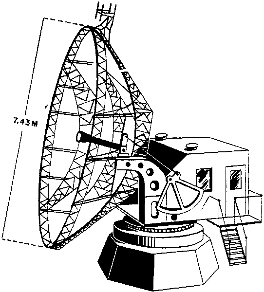
Giant Wurzburg=Wurzburg Riese (FuMO214).
Directory of German Radar Equipment 1945 - TME11-219 (War
Department Technical Manual)
Have received some requests for pictures
showing the cabin of Wurzburg Riese, but I am careful to borrow
other persons pictures,
suggest you buy some books yourself, check:
Fritz Trenkle, "Die deutschen Funkmeßverfahren bis
1945"
pg 47 - Innenansicht Wurzburge Riese
pg 52 Gerätesatz des Mannheimgerätes
pg 54. Blick auf den Ansbachgeräte

Oscilloscope display for Wurzburg Riese (spotted at NRHF auction
in March 2004)
First EME - Earth-Moon-Earth
(Erde-Mond-Erde) - echoes ever experienced.
See "Die deutschen Funkmeßverfahren bis 1945"
(Fritz Trenkle) pg 94:
3.2.15 Würzmann (- not Wurzburg Riese!)
Ein weiteres Versuchsgerät war von der Firma Telefunken (Stepp)
bei Gören auf der Insel Rügen errichtet worden. Diese Anlage
"Würzmann" verwendete einen in der Sendeleistung
verstärkten "Würzburg"-Gerätesatz (560MHz, 120kW)
mit einer Wassermann
ähnlichen Antenne, bestehend aus zwei vertikalen Reihen mit 16
Feldern des DMW-Richtfunkgerätes DMG4K "Michael", die
an zwei
feststehenden Gittermasten von 36m Höhe befestigt waren. .....Anfang
1944 erzielte dieses Gerät auch die ersten Echos vom Mond
(Entfernung 384000km, Laufzeit der elektrischen Wellen ca 2,5
Sekunden),
da gelegentlich eine bestimmtes starkes Echo erst ca 2 1/2
Sekunden nach Abschaltung des Senders verschwand
[Stepp, W., Physikalische Grundlagen der
Funkortung, in: Bücherie der Funkortung Band 1, Best-Nr. 5010,
Dortmund 1953]

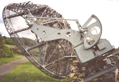
German radar (#5) exported to
Sweden in 1950 and returned to Mövik Kanonmuseum in 1999.
What happened to the German radars after the war?
They wer not immediately
removed, but the Wassermann were felt unsafe as the children were
climbing in it, and was
removed after few years. The FuMO214 Wurzburg's were sent to
Swedish observatory in 1950, and one is still in use
for laboration. The others are wrecked, but one mount is
transported to Mövik and planned to be used at the museum,
together with the parabolic dish from Brattaasen Flekkeröy which
was found downside the mountain 5 years ago and
could be seen at Mövik Kanonmuseum.
It is supposed that the Wurzburgs from Tromÿ (Arendal) and
Justöy (Lillesand) were also sent to Sweden
The German radars from Lista were sent to Oslo University, and
stored at Harestua until they were damaged.
The Wurzburg Riese at Helgöya (Ny Hellesund) were blown in the
60's because some neighbours didn't like
to see some German remainders. See page K.53 for more information (in
Swedish/Norwegian)
IMPORTANT
NOTE: To
understand German radar situation it is important to ascertain
that the different German units did not speak to each other, so
Kriegsmarine lived in a different world than Luftwaffe. Don't mix
the different installations together, they were even referred in
different documents after WW2. It was probably more interesting
installations that described on different internet pages by
persons who hardly understand radar, so it was on Flekkeröy, but
an important description to understand the situation is shown on
the Danish site under Himmelbettverfahren
1943-45 [shows most of the
installations I believe has been on Flekkeröy (not Freya
Fahrstuhl)]
Rettelse (Correction):
Fikk en beskjed om at begge Wurzburg Riese fra Marka på
Lista etter krigen (antakeligvis rundt 1950) først ble de
flyttet til
Solobservatoriet på Harestua. Den ene står der fortsatt,
riktignok med feil antenne og uten hus. Den andre står på Sola
Flymuseum sammen med begge parabolene. Arbeidet med å restaurere
denne har imidlertid stoppet opp.
Links to other pages
and sites:
 Norwegian WW2 Discussion Forum
 German Radar sites in Norway 1940-1945
994 Index
for all the different pages on this site
K. German
coast fortresses sites in Agder
k58.
Flugmelde-Organisation
e98. Tactical radars (written by Gordon L Adams G3LEQ, Radio
communication, June 2001)
29a. IFF
transponder for Freya type radar
E.
Technical information for German radio/radio equipment
a12 further data
35b Further info for
source of information
e71a Suggestions for
books to buy
e71 Available books about
German equipment
e73
Further info from English language books
e76 Surplus equipment described in
some magazines
e77. Funkmeßgeräte-Entwicklung bei der C. Lorenz
AG 1935-1945
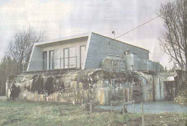
Krigsbunker ble fritidsbolig
(Fædrelandsvennen 29/12-03).

Correspondence: You may write in English or German, Danish or
Swedish, but I will reply in English (or Norwegian)
Updated: 2005.03.16